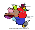
Luis miguel (talk | contribs) (it's the map of the provinces of rodas) |
Luis miguel (talk | contribs) (Luis miguel uploaded a new version of File:ProvinceRodas.png) |
(No difference)
| |
Revision as of 02:47, 15 April 2024
Summary
it's the map of the provinces of rodas
File history
Click on a date/time to view the file as it appeared at that time.
| Date/Time | Thumbnail | Dimensions | User | Comment | |
|---|---|---|---|---|---|
| current | 00:30, 17 June 2024 |  | 454 × 395 (25 KB) | Luis miguel (talk | contribs) | Addition of the general government of goiás |
| 22:20, 9 June 2024 |  | 454 × 395 (26 KB) | Luis miguel (talk | contribs) | Addition of Guyana and Cayenne which was purchased for free | |
| 02:47, 15 April 2024 |  | 454 × 395 (25 KB) | Luis miguel (talk | contribs) | updating the country's borders and the creation of the military government of Mato Grosso do Sul | |
| 03:36, 18 March 2024 |  | 454 × 395 (23 KB) | Luis miguel (talk | contribs) | it's the map of the provinces of rodas |
You cannot overwrite this file.
File usage
The following 2 pages use this file: